 Gallery

To answer these Questions (and make your life easier), it is necessary to know how to draw the sketch and place the given values on it. If you don't know how to do this yet, I suggest you first take a look at this topic (click!)
► An aircraft passes position A (60° 00 minutes N 120° 00 minutes W) on route to position B (60° 00 minutes N 140° 30 minutes W). What is the great circle track on departure from A?
Answer: 279
Make the sketch with the 2 meridians converging at the top (Northern Hemisphere) and draw the rhumb line in it.
We are flying towards the West so RLT is 270° . At A we can see that the GCT is bigger than the RLT, the difference being the conversion angle.
Conversion angle = 0.5 x (Ch long x Sin(lat))
Conversion angle = 9°
270° + 9° = 279° GCT
► A great circle track joins positions A (59°S 141°W) and B (61°S 148°W). What is the difference between the great circle track at A and B?
Answer: It increases by 6°
Make the sketch with the 2 meridians converging at the bottom (Southern Hemisphere) and draw the rhumb line in it.
We are flying towards the west which makes our RLT 270°. At A we see that the GCT is smaller than the RLT (the difference being the conversion angle).
Conversion angle = 0.5 x (Ch long x Sin(mean lat))
Conversion angle = 3°
So at A, the GCT = 270 - 3 = 267°
And at B, the GCT = 270 + 3 = 273°
Difference between position A and B = Increased by 6°
► Given: Great circle from P to Q measured at P = 095° Southern Hemisphere, conversion angle P - Q = 7°. What is the rhumb line track P - Q?
Answer: 088
Make the sketch with the meridians converging at the bottom (Southern Hemisphere) and draw the rhumb line in it.
The GCT at P is measured to be 95° meaning we are flying towards the East. At P we see from the sketch that the RLT is smaller than the GCT (95°), by the conversion angle.
Conversion angle is given as 7° so 95 - 7 = 88° RLT
► The angle between the true great circle track and the true rhumb line track joining the following points: A (60°S 165°W) B (60°S 177°E), at the place of departure A is:
Answer: 7.8°
Difference between GCT and RLT = Conversion Angle (which is half the convergency)
Convergency = Ch Long (18°) x Sin(60°) = 15.6°
Conversion angle = 7.8°
► Given: Value for the ellipticity of the Earth is 1/297 . Earth semi-major axis, as measured at the equator, equals 6378.4 km. What is the semi-minor axis (km) of the Earth at the axis of the Poles?
Answer: 6356.9
(1/297) x 6378.4 = 21.5
6378.4 - 21.5 = 6356.9
► If an aeroplane was to circle around the Earth following parallel 60°N at a ground speed of 480 kt. In order to circle around the Earth along the equator in the same amount of time, it should fly at a ground speed of:
Answer: 960 kt
The distance at the equator is double that of the distance at the 60° parallel. The speed would therefore also have doubled.
You can also solve this by calculation but you'll need to remember the distances for this;
Circumference at 60°N = 10 800 NM
10 800 / 480kt = 22 hours 30 minutes
Circumference at equator = 21 600 NM
21 600 / 22.5 = 960kt
► Given: Position A is N00° E100° , position B is 240°(T), 200 NM from A. What is the position of B?
Answer: S01° 40minutes E097° 07minutes
Try to picture the scenario. We are on the equator and B is in the direction 240°(T), South-West direction. B is therefore in the southern hemisphere (cancels out 2 answers)
We are going to a South-West direction so the longitude E100° should be decreasing (going towards the prime meridian). The answer stating "E101° 40min" is therefore also canceled out
► The following waypoints are entered into an inertial navigation system (INS):
WPT1: 60N 30W
WPT2: 60N 20W
WPT3: 60N 10W
The inertial navigation is connected to the automatic pilot on the route WP1 - WP2 - WP3. The track change in passing WPT2 is:
Answer: A 9° decrease
Sketch 2 diagrams next to each other for the Northern hemisphere, 1 diagram contains meridians for WP1 and WP2 and the second diagram contains the meridians for WP2 and WP3.
A INS follows the great circle track so find out the values for the waypoints. Finally, look at the difference between the GCT in diagram 1 and the GCT in diagram 2

►You are flying from A (30°S 20°E) to B (30°S 20°W). At what longitude will the GC track equal the RL track?
Answer: 0°E/W
GCT and RLT are equal at exactly halfway between the 2 positions. In our case (20°E and 20°W) that will be on 0°E/W
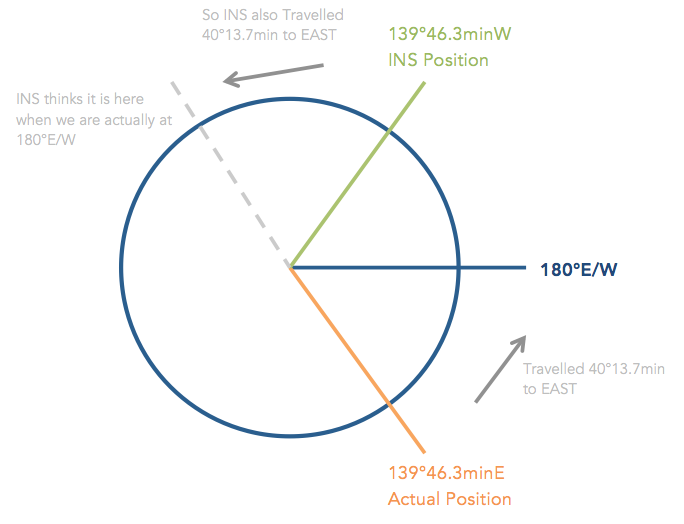
► As the INS position of the departure aerodrome, coordinates 35°32.7minN 139°46.3minW are input instead of 35°32.7minN 139°46.3minE. When the aircraft subsequently passes point 52°N 180°W, the longitude value shown on the INS will be:
Answer: 099°32.6minW
1) What we are ACTUALLY doing:
We start at 139°46.3'E and travel to 180°E/W
We have travelled 40° 13.7' in an Easterly direction
2) What the INS thinks:
While we were travelling 40°13.7' to the EAST, the INS also travelled 40°13.7' to the EAST (anti-clockwise on the sketch).
139° 46.3'W - 40°13.7' = 099°32.6'W (Although we travelled East, we are still in the Western hemisphere)
Sketch: (Viewing from the top down // Centre is North Pole)
► Given:
Waypoint 1: 60° S 030°W
Waypoint 2: 60° S 020°W
What will be the approximate latitude shown on the display unit of an inertial navigation system at longitude 025°W?
Answer: 060° 06min S
► In the Northern Hemisphere the rhumb line track from position A to B is 230°. The convergence is 60 and the difference in longitude is 10°. What is the initial rhumb line track from B to A?
Answer: 050°
A rhumb line track keeps its value so at B it will still be 230°. The reciprocal of 230° is 50°.
► An aircraft flies from waypoint 7 (63° 00min N, 073° 00minW) to waypoint 8 (62° 00min N, 073° 00min W). The aircraft position is (62° 00min, 073° 10minW). The cross track distance in relation to the planned track is:
Answer: 4,7 NM R
From position 7 to 8 we would have to fly straight down (South) on the same meridian. However, the aircraft ended up at 073° 10minW which means 10minutes to the RIGHT of waypoint 8.
Find the distance via departure = Ch long (10') x Cos(62) = 4.7 NM
► Position A = (30° 00.0minN , 175° 23.2minW)
Position B = (30° 00.0minN , 173°48.1minE)
For the route from A to B the:
Answer: Rhumb line distance is 578 NM
1) Calculate the rhumb line distance
Departure = Ch Long (10.8 x 60) x Cos(30) = 561 NM (closest answer 578NM)
2) Calculate the great circle track (to check the other possible answers)
Draw the sketch for the northern hemisphere. Calculate the great circle at A via conversion angle and then find great circle at B. Both do not match the possible answers given which only leaves 1 correct answer (or at least closest answer
