 Gallery

► (Refer to Jeppesen Training Route Manual - PARIS CDG - chart 20-3)
Planning an IFR flight from Paris Charles de Gaulle to London. SID is ABB 8A. Assume:
Variation: 3°W
TAS: 430 kts
W/V: 280/40
Distance to top of climb: 50NM
Determine the magnetic course, ground speed and wind correction angle from top of climb to ABB 116,6.
Answer: MC 349° , GS 414 kts , WCA -5°.
What we need to extract from the chart is the magnetic course from the position we are at. With the MC and the given values we can use the navigation computer to find the answer.
1) Find chart 20-3 and add up all the distances until ABB:
Total Distance = 74.5NM (2 + 7 + 0.5 + 9 + 56)
Subtract from this the distance to TOC = 24.5NM (74.5 - 50)
This means that we are 24.5NM from and inbound to the station ABB 116.6.
You can either calculate and mark the position on the chart but it is clear that we are on the final black arrow inbound to the station.
Our magnetic course is thus 349°
2) Find the other values with the navigation computer
MC 349° - 3°W = 346° True Course
Set 346° (TC) on top of the navigation computer (wind side) and add the wind. At the intersection between wind speed and TAS we can read the WCA (into the wind) 5° left (-5) and the ground speed inside the circle 414kt.
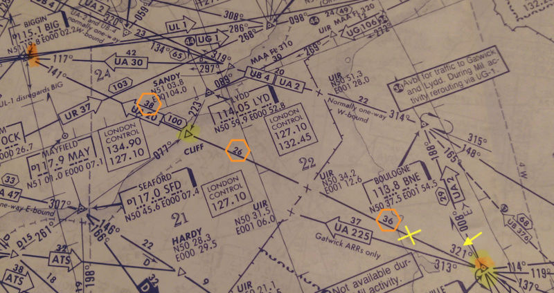
► (Refer to Jeppesen Training Route Manual - chart "E HI 4" - CAA Edition + STAR chart for LHR 10-2 + ILS DME RWY27R chart for LHR 11-4)
Planning an IFR flight from Paris to London (Heathrow). Assume:
STAR: BIG 2A
Variation: 5°W
Enroute: TAS 430 kts
W/V: 280/40
Descent distance: 76NM
Determine the magnetic course, ground speed and wind correction angle from ABB 116,6 (50°08.1minN 001°51.3minE) to top of descent.
Answer: MC 321° , GS 396 kts , WCA -3°.
Almost the exact same method as the Question above. There are different charts provided but we can find all the values we need from the E HI4 CAA (saves time).
1) Open chart E HI4 CAA and find the route from ABB 116.6 to BIGGEN (where our STAR BIG 2A will end)
From the chart, add up all the distances to come to a total of 100NM
(62 from ABB to Cliff + 38 from Cliff to BIG)
Subtract from this the descent distance of 76 = 24NM
So we are 24NM outbound from ABB towards Cliff which makes our magnetic course 321°
2) Find the other values with the navigation computer
321 MC - 5°W = 316 True Course
Now put all those values in the navigation computer as we did above and find:
GS = 396kt
WCA = 3° left (-3)
Planning an IFR flight from Paris Charles de Gaulle to London. SID is ABB 8A. Assume:
Variation: 3°W
TAS: 430 kts
W/V: 280/40
Distance to top of climb: 50NM
Determine the magnetic course, ground speed and wind correction angle from top of climb to ABB 116,6.
Answer: MC 349° , GS 414 kts , WCA -5°.
What we need to extract from the chart is the magnetic course from the position we are at. With the MC and the given values we can use the navigation computer to find the answer.
1) Find chart 20-3 and add up all the distances until ABB:
Total Distance = 74.5NM (2 + 7 + 0.5 + 9 + 56)
Subtract from this the distance to TOC = 24.5NM (74.5 - 50)
This means that we are 24.5NM from and inbound to the station ABB 116.6.
You can either calculate and mark the position on the chart but it is clear that we are on the final black arrow inbound to the station.
Our magnetic course is thus 349°
2) Find the other values with the navigation computer
MC 349° - 3°W = 346° True Course
Set 346° (TC) on top of the navigation computer (wind side) and add the wind. At the intersection between wind speed and TAS we can read the WCA (into the wind) 5° left (-5) and the ground speed inside the circle 414kt.
- View on Chart:

► (Refer to Jeppesen Training Route Manual - chart "E HI 4" - CAA Edition + STAR chart for LHR 10-2 + ILS DME RWY27R chart for LHR 11-4)
Planning an IFR flight from Paris to London (Heathrow). Assume:
STAR: BIG 2A
Variation: 5°W
Enroute: TAS 430 kts
W/V: 280/40
Descent distance: 76NM
Determine the magnetic course, ground speed and wind correction angle from ABB 116,6 (50°08.1minN 001°51.3minE) to top of descent.
Answer: MC 321° , GS 396 kts , WCA -3°.
Almost the exact same method as the Question above. There are different charts provided but we can find all the values we need from the E HI4 CAA (saves time).
1) Open chart E HI4 CAA and find the route from ABB 116.6 to BIGGEN (where our STAR BIG 2A will end)
From the chart, add up all the distances to come to a total of 100NM
(62 from ABB to Cliff + 38 from Cliff to BIG)
Subtract from this the descent distance of 76 = 24NM
So we are 24NM outbound from ABB towards Cliff which makes our magnetic course 321°
2) Find the other values with the navigation computer
321 MC - 5°W = 316 True Course
Now put all those values in the navigation computer as we did above and find:
GS = 396kt
WCA = 3° left (-3)
- View on Chart: